An automated GIS toolbox for watershed delineation with lakes
Project description
BasinMaker - An automated GIS toolbox for watershed delineation with lakes
Overview
Before introducing the methodology and application procedure of the BasinMaker, the differences between routing structure without considering lake and routing structure with lakes defined by BasinMaker will be introduce in this section.
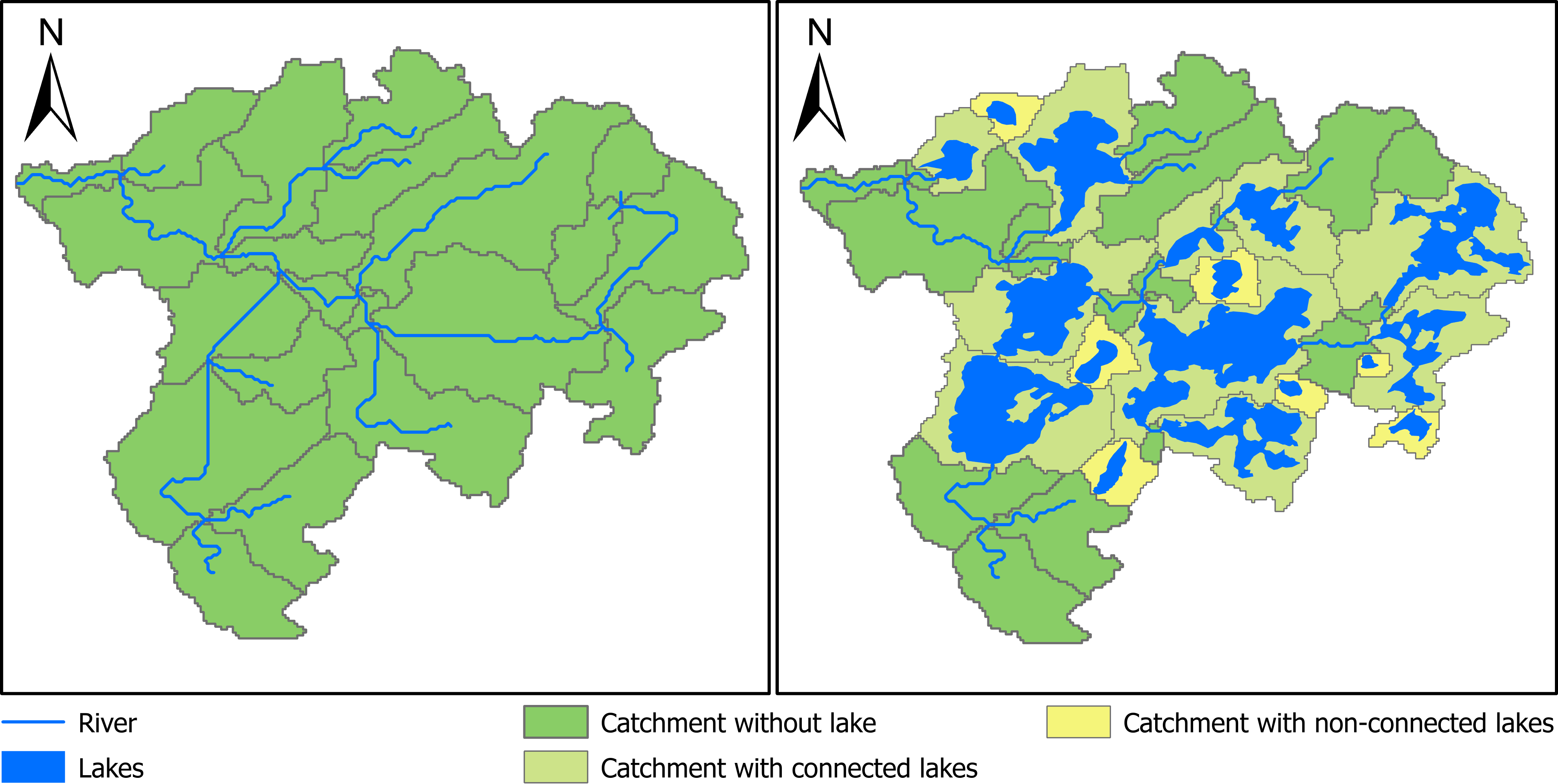
A routing structure without considering lakes is showed in Figure 1A. Catchments defined by river reaches in this routing structure are showed in Figure 1A. In hydrological models, the streamflow is only explicitly simulated at the outlet of each catchment. It is not explicitly simulated at the mid of the river segment or any point inside each catchment. Thus, when using this routing structure to build hydrological model, we could obtain the simulated streamflow at end of each reach or catchment outlet in Figure 1A, but the inflow and the outflow of each lake showed in Figure 1 cannot be simulated. Thus, the impact of lake on the routing process modeling such as flow attenuation can not be correctly modeled.
An example of routing structure with lakes generated by the BasinMaker is shown in Figure 1B. Lakes are divided into two categories by the BasinMaker: (1) connected lakes (CL), which indicates lakes directly connected with the river network; and (2) non-connected lakes (NCL), which denotes lakes not connected with the river network (Figure 1B). The resolution of the river network is defined by user provided flow accumulation threshold. Both CL and NCL defined here are within the drainage area of the watershed and water released from both CL and NCL will move to the outlet of the watershed. Thus, the definition of NCL here is not the same as the definition of none contributing area, in which runoff generated will not move to the watershed outlet.
For both CL and NCL, the BasinMaker will use lake polygon to identify each lake’s inlets and outlet and then represent each lake as a lake catchment (LC) shown Figure 1B. A lake catchment will fully cover the lake polygon and its outlet is the same as the outlet of the lake (Figure 1B). At the same time, each inlet of the CL will also be identified as a catchment outlet (Figure 1B). In this way, both inflow and outflow of each lake can be explicitly simulated by the semi-distributed hydrological models.

Documentation
The BasinMaker is developed within python3 environment and using several basic raster and vector functions in QGIS and GRASS GIS. The list of functions from GRASS and QGIS and have been used by BasinMaker can be found in here
-
The installation of the toolbox can be found in here
-
List of all tools provided by BasinMaker can be found in here
Example usage
Example to delineate lake-river routing structure from DEM
-
An example to delineate lake-river routing structure with OIH 30 m DEM can be found here
-
An example to delineate lake-river routing structure with HydroSHEDS 90 m DEM can be found here
-
An example to delineate lake-river routing structure with MERIT 90 m DEM can be found here
Example to post processing existing lake-river routing structure
-
The application procedure to part of the existing lake-river routing structure can be found in here
-
The application procedure to simplify an existing lake-river routing structure by increasing catchments minimum drainage area can be found in here
-
The application procedure to simplify an existing lake-river routing structure by removing lakes with lake area smaller than given lake area threshold can be found in here
-
The application procedure to generate hrus and raven model inputs can be found in here
Example to 'parallel' processing
- The application procedure to working with large domain with high resolution DEM here
Citation
Han, M., Mai, J., Tolson, B. A., Craig, J. R., Gaborit, É., Liu, H., and Lee, K. (2020a): Subwatershed-based lake and river routing products for hydrologic and land surface models applied over Canada, Canadian Water Resources Journal, 0, 1-15. (publication)
Han, M. et al. (2020b): An automated GIS toolbox for watershed delineation with lakes In preparation.
Han, M., Mai, J., Tolson, B. A., Craig, J. R., Gaborit, É., Liu, H., and Lee, K. (2020c): A catchment-based lake and river routing product for hydrologic and land surface models in Canada (Dataset) Zenodo. (dataset)
Acknowledgments
Funded under Lake Futures project of Global Water Futures program.


Project details
Release history Release notifications | RSS feed
Download files
Download the file for your platform. If you're not sure which to choose, learn more about installing packages.
Source Distribution
Built Distribution
Hashes for basinmaker-0.0.2-py3-none-any.whl
| Algorithm | Hash digest | |
|---|---|---|
| SHA256 | f918d387fbd026b6d33cdaba0c1d520dc790bf966afc6438c509d2371fb2d2fd |
|
| MD5 | f517a6fabf90d9fec14e446c2d6de7b3 |
|
| BLAKE2b-256 | c8386eefa629e5baea06d64fdc46a9d7e17407fadb8c4906a42b7600a79542dd |


